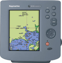
The Raymarine Raychart 435 GPS Receiver and Chart PlotterMarine Navigation has come a long way since Dead Reckoning, Inertial Navigation Systems and VHF Applications. The Ultra High Frequency backed Global Positioning System has made it possible to plot you within 10 meters of your actual position (3 feet with DGPS support) with a feed from just 3 of 24 dedicated satellites.The Raymarine RC435 is an interactive GPS receiver featuring a high resolution color display, point and shoot navigation and vector cartography. The RC435 using its proprietary SmartRoute technology automatically allocates waypoint from previous tracks, which makes chart work much easier. The device can store 500 waypoints and 20 routes, and comes with an expandable memory slot. No doubt a true chart plotter, Raymarine?s even managed to duplicate the traditional marine chart colour scheme. Unboxing the Raymarine RC435 is a pleasant surprise since they?ve catered for a lot that?s been over looked earlier by way of the bundled protective front cover and external antenna for indoor use though not many users have had an issue with capturing a feed. As against its competitors and other similar GPS Chart plotters the Raymarine RC435 is most preferred for its 6 inch Direct Sunlight Viewable Display which minimizes glare making it an ideal choice for open cockpit and main deck usage. The display is robust and water resistant. Another quirk with GPS receivers is that the vessel orientation symbol in the centre often disappears at high zoom factors, which tends to make the user lose his bearings momentarily; the RC435 has rectified this. There aren?t many aftermarket accessories available for the Raymarine Raychart 435 barring a few carry cases and screen protectors which makes it all the more evident that this little device is all you need on your next marine expedition. There?s a lot more to be said about Marine GPS Receivers and Chart Plotters, this is where we sign off though. Ahoy! 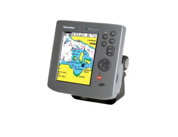
Copyright © Hybrid Content Pvt. Ltd. |